NEW YORK (AP) — A chaotic climate phenomenon is intensifying heavy rains and floods in the Southwest, experts say.
A natural warming cycle called El Niño is sizzling Pacific Ocean waters, leaking moisture into the air that can fuel passing storms. Such El Niño events can happen irregularly every couple of years, but scientists say the latest iteration is particularly extreme — and it’s just getting started, with impacts expected for several more months.
“We’ve had super El Niños in the past, but this is a super duper El Niño,” said meteorologist Jeff Masters of Yale Climate Connections.
The phenomenon wasn’t the only cause of the severe storms and it’s difficult to attribute any single event to it. Still, scientists say this supercharged El Niño is making heavy rains more likely and intense across the Southern U.S. The effects of those storms can be felt more strongly in desert regions, where the land doesn’t absorb water as well.
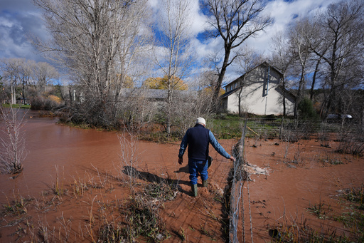
Flash floods on Sunday prompted evacuations across northern New Mexico and central Arizona, and a Colorado ski town braced for its main river to rise to catastrophic levels. And just last week, another wet storm subjected southwestern states to days of flooding.
Over 20 trillion gallons of water have fallen on the Four Corners states and Nevada in the past two weeks, according to calculations by former National Oceanic and Atmospheric Administration chief scientist Ryan Maue.
Experts say this year’s extreme El Niño is creating more ideal conditions for storms. It’s adding more moisture to the air, which is perfect fodder for downpours to draw upon. And it’s shifting wind patterns across the globe, redirecting strong air currents toward the Southwest that can stir up that moisture.
“The likelihood of big precipitation in the Southwest interior does go up this time of year, but we’re seeing it to a degree we actually haven’t seen before,” said climate scientist Daniel Swain with the University of California Agriculture and Natural Resources.
This El Niño is sloshing warmer waters into new places, but the world’s oceans are already hotter than they used to be because of human-caused climate change. That means even more sweltering extremes are possible.
“The fact that the ocean temperatures are already warmer than they were, say, 100 years ago, makes these El Niño situations even more intense,” said meteorologist Randy Cerveny with Arizona State University.
The phenomenon is changing weather patterns around the world: regions including Peru and Ecuador are also seeing record-breaking flooding, Swain said. Parts of southeast Asia, like Indonesia, are drier than usual.
The El Niño event is expected to peak in December, when it can more strongly harness certain air currents called jet streams to produce more extreme storms across the western U.S. After that, experts say its onslaught could continue for months.
“The dice are certainly loaded for more heavy storms this winter and spring,” said Park Williams with UC San Diego’s Scripps Institution of Oceanography in an email.
The impacts of an El Niño aren’t wholly bad, Cerveny said: it can bring rainfall and moisture to drier areas like the Southwest and fill up reservoirs. At the same time, storms and floods can pose a danger to people and property.
To stay safe, experts recommended watching the forecast, planning ahead and heeding evacuation warnings from local authorities.
“We’re not at the peak of the heating in the Pacific Ocean. So yes, we will see more of these particular events,” Cerveny said.
—-
The AP’s climate and environmental coverage receives financial support from multiple private foundations. The AP is solely responsible for all content. Find AP’s standards for working with philanthropies, a list of supporters and funded coverage areas at AP.org.